One of the first things that struck me when I selected this as a project, was that a Google search for “Prazinburk Ridge” yielded absolutely no results whatsoever. It was mentioned in Duggy’s diary, as transcribed by historian David Gronow and provided to my brother Steve, the author of Duggy’s biography, on which my short film is based. Other than that, as far as the internet is concerned at least, it doesn’t seem to have existed.
Whilst this is good for a film (since anyone who searches for the film title will absolutely find it), it set my OCD off. Where was this bloody ridge I was making a film about?
In discussions Steve and I concluded that the name must have been a local variation of something else, or had been mis-heard, mis-quoted or mis-remembered at some point. “The other texts that have quoted [Duggy’s diary] stuck with Prazinburk,” Steve said. “The editor questioned it and had the same opinion.”
As I fell deeper down the rabbit-hole of World War One research, my curiosity got the better me. I had to know. I resolved to have a break from working on the film and take my own research trip to Ypres, to try and solve the mystery.
When I started the film, I hadn’t done any research at all really. I didn’t know what it should look like, and the film has changed accordingly as my research has continued. My initial design had the “ridge” as a pile of mounded-up dirt, having been dug out of a trench, but that’s not at all what a ridge is. It’s just a hill, and not a particularly high one at that. It’s slightly-elevated ground that would offer an obvious strategic advantage on the mostly-flat farmland around Ypres.

A display from the museum at Passchendaele. No “Prazinburk” here, but there is a likely contender to be the ridge in the story...
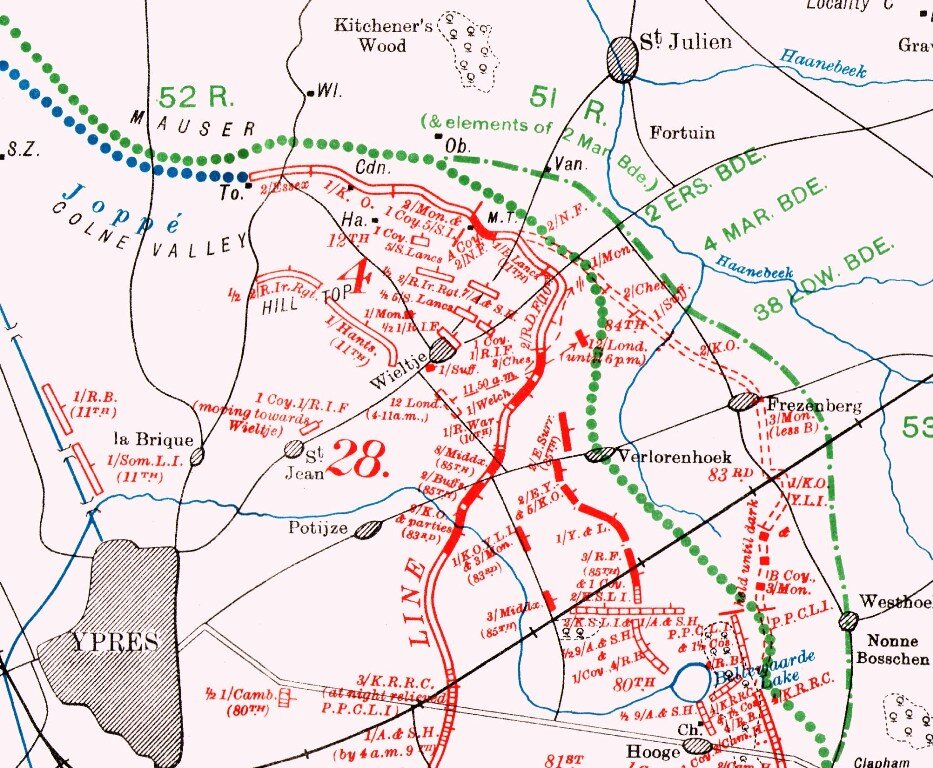
Neil Bates is a friend who is a history teacher and keen Great War historian, and had agreed to help me with research early in the film’s development. He was the first to suggest that “Prazinburk” wasn’t a known place, and that maybe it was Frezenberg, which was a village outside Ypres with a “ridge”. While we couldn't be sure, it was a good starting point.
Recently, I stood at the Frezenberg Ridge Irish Memorial and wondered if I was at the right place.
The particular adventure that my film covers in Duggy’s storied life takes place on October 30th, 1917, during the Third Battle of Ypres, or as it is known by its scars upon the British psyche, simply “Passchendaele”.
Duggy was part of the Army Service Corps, in an Artillery Battery supplies unit, transporting shells to the Batteries. On this particular occasion they suffered a gas attack at the same time as incredibly intense shelling from the German guns, while unloading shells at the Battery, and disaster befell Duggy’s unit.
If I was on the correct ridge, Duggy’s team would have been bringing shells from the direction of Ypres, to the south-west; and the 18-pound guns would be shelling in the direction of Passchendaele to the north-east, where the German front line was, less than 6km away. The shells fired from an 18-pound Artillery gun could travel up to 6km, so the maths works out.

From Major Holt’s Battle Map of The Ypres Salient. The Ridge is actually closer to Bremen Redoubt than where Frezenberg is labelled. The Irish monument where I stood is labeled 22a.
It must be this one, then. Could I place the location exactly? Very possibly...
According to Steve’s book, based on the diaries of Duggy, when he approaches the Battery, there is a lake of stagnant water surrounding the road. So the guns were obviously at the bottom of the ridge, where water would gather, firing over it. It’s likely there would be a trench dug into the ridge (probably already there from earlier battles) to defend it in case of a German breakthrough.

This is where I stood, a place identified as the Ridge. There’s a natural stream not far away, indicating the lowest point of the ridge and a likely place for the intense rainfall of that period to gather.
This map is dated 1915, and shows the road that leads out from the Menin Gate in Ypres, through Potyze and to Frezenberg, and the road still exists today. Since there are no other roads here we can assume that a “formal” road from this road to the battery did not exist and the trucks would be driving along a mud track for the last part of the journey. However, this road may still exist now. (Source: Jeremy Banning)
On returning from Ypres, I decided the best thing I can do was visualise it the way I do everything else! So I loaded the GIS data for Frezenberg into Blender. Of course, the land is largely flat, the exaggerated ridges of the first image above aren’t like that. But the GIS data is applied as a displacement map, and pushing the strength of it reveals the contours of the ground...

Exaggerating the 3d data reveals the contours of the ground…
As expected, the stream forms the lowest points, and a climb up from this stream is where you would now find the Frezenberg Ridge memorial. So we’ve established that the battery must have been:
-Near water at the bottom of the Ridge;
-Facing Passchendaele to the north-east;
-A short drive from what is now the N332 road from Ypres;
So all I can do, in lieu of having a period map which spells it out precisely (which I don’t have but may exist), is make an educated guess. This is it…

Obviously our educated guess is presented here on our wildly-exaggerated terrain. I’m making an assumption that this road was created during the war.

Where I stood on the ridge, looking down towards where the battery would have been - in the gap in the trees.

The view of the road to Frazenberg Ridge today, looking through the gap in the trees from the other side.

Duggy and his team approach Prazinburk Ridge in this screen-grab from the latest cut of the film.

So, what does this all mean? Have we got it wrong, should I rename the film?
I don’t think so. This is Duggy’s story. He wrote it as Prazinburk Ridge. So it’s Prazinburk Ridge, for our purposes at least - but at least we know where this story took place.
After both the book and the film are out I hope to be able to make contact or hear from people who might have more details. The trip to Ypres will become an annual one, and I hope next year my brother can join me and we’ll go to the spot where Duggy’s time in the Great War came to an end.
The Man of All Talents: The Extraordinary Life of Douglas Clark is available October 5th from all major outlets via Pitch Publishing.